| Measuring an arc of the meridian |
.
|
|
|
|
Summary
The Arc of the Meridian is an imaginary line on the meridian (runs true North – South), drawn anywhere on earth. The Scientific value of such a line is that, if the line is long enough (at least 70 km (43.4 mile)) and surveyed with great accuracy, then the curvature of the earth can be measured. Add to that principle the accurate measurement of the latitudes (how far north or south you are from the equator) at the two far ends of the line, and you measures the distance of the line by independent means to the physical measurement. This gives you an extra value to test measurement against. In other words: you can measure the curvature of the Earth, and more than that, the size and shape of the Earth. But for the method to work, measuring the latitudes, or in more layman’s terms, getting the vertical correct is critical.
The modern pre-conceived idea, that Europeans in the Middle Ages believed that the earth was flat, is largely a myth. (Source) In the eighteenth century everyone knew that the earth was approximately round. Being scientist, they had to prove it. The Arc of the Meridian was measured at a few places e.g. America, Russia, Germany and France, proving that the Northern Hemisphere was round. But, being scientist, the same had to be proven for the Southern Hemisphere.
Lacaille (also known as Abbe De La Caille) was sent to Cape Town to do the measurements. Due to a mistake, his measurements showed that the earth was pear shaped, round on top (Northern Hemisphere), but bulged at the bottom (Southern Hemisphere). Maclear re-measured the Arc of the Meridian and, identified and corrected the mistake, which proved that the earth is round. Maclear’s Beacon on top of Table Mountain thus symbolises that the earth is round. (With a bit of poetic license) |
Persons involved.
Lacaille
“The Abbe de la Caille, as he was later to become, laid the foundations of Southern Hemisphere astronomy. He 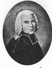 was the predecessor of all the later pioneers such as Maclear, Herschel and Gill. It has sometimes been suggested that La Caille’s achievements was largely vitiated by the lack of adequate instrumentation for his basic work, but a scientist of the stature of Sir Thomas Maclear did not think so and neither did Sir John Herschel. Hershel’s survey of the Southern sky is now generally held by astronomers to have been the true starting-point of modern scientific work in this field. Had La Caille been able to use modern-type instruments as well, his work would have advanced our knowledge of Southern Hemisphere astronomy by almost a hundred years. As it was, he showed later generations how to set about an intensive observing programme and his diligence in pursuing it, became legendary. It is not from pure sentiment that a piece of charcoal from one of his signal fires is preserved to this day at the Cape Observatory. … and with several excellent works on mathematics and astronomy to his credit, La Caille was singled out. It was because of his proven competence and wide knowledge that when he later made an error in one of his major geodetic measurements, men of the calibre of Maclear and Herschel went to enormous lengths to discover how the calculations of such an expert could possibly have gone wrong. Establishing the cause of La Caille’s mistake, they reasoned, important scientific principles could be unearthed. They were right. [Copied Moore, pp. 29 – 31.] was the predecessor of all the later pioneers such as Maclear, Herschel and Gill. It has sometimes been suggested that La Caille’s achievements was largely vitiated by the lack of adequate instrumentation for his basic work, but a scientist of the stature of Sir Thomas Maclear did not think so and neither did Sir John Herschel. Hershel’s survey of the Southern sky is now generally held by astronomers to have been the true starting-point of modern scientific work in this field. Had La Caille been able to use modern-type instruments as well, his work would have advanced our knowledge of Southern Hemisphere astronomy by almost a hundred years. As it was, he showed later generations how to set about an intensive observing programme and his diligence in pursuing it, became legendary. It is not from pure sentiment that a piece of charcoal from one of his signal fires is preserved to this day at the Cape Observatory. … and with several excellent works on mathematics and astronomy to his credit, La Caille was singled out. It was because of his proven competence and wide knowledge that when he later made an error in one of his major geodetic measurements, men of the calibre of Maclear and Herschel went to enormous lengths to discover how the calculations of such an expert could possibly have gone wrong. Establishing the cause of La Caille’s mistake, they reasoned, important scientific principles could be unearthed. They were right. [Copied Moore, pp. 29 – 31.]
Sir George Everest
Everest, The famous Surveyor General of India after whom the highest mountain in the world was later named, visited the Cape in 1820. He had ample experience of the effect that mountains have in surveys. Everest inspected La Caille’s beacon and postulated that the gravitational attraction of mountains (in this case Table Mountain and Piketberg) could have caused anomalous disturbances on La Caille’s plumb line readings, causing the confusion. [Amod, p. 3.;Keay, p.87. ]
Sir Thomas Maclear
IIn 1834 the post of H M Astronomer at the Cape was allotted to Thomas Maclear. South Africa owes a great deal 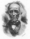 to this man, for it was he who put the Observatory on a really firm footing, as well as carrying out important work on his own account and paving the way for his brilliant successors. to this man, for it was he who put the Observatory on a really firm footing, as well as carrying out important work on his own account and paving the way for his brilliant successors.
In spite of a strangely improbably early career for such a position- he was a medical doctor by profession and an astronomer only by inclination – he devoted himself wholeheartedly to his task. |
Lacaille’s measurement
“In the middle years of the eighteenth century, the lack of astronomical stations in the Southern Hemisphere was greatly hampering scientists in their basic work. Firstly, a Southern Arc of the Meridian was needed to complement the measurements already made in the Northern Hemisphere to determine the exact shape of the Earth. That the Earth must be oblate – that is to say, flattened at the poles – was generally suspected. Results from the North indicated as much and if Newton’s theory of gravitation was correct, the Southern half of the earth should be the same shape as the Northern half. Nobody could be sure; it had to be scientifically proved.
There was the urgent need for a reliable catalogue of the Southern stars to aid mariners in navigating their ships. The existing catalogues were, to put it kindly, sketchy as well as incomplete. By working in conjunction with a second observatory in the North at approximately the same longitude, the exact longitude of the Cape itself could be established. Magnetic variation studies were also on the programme, as well as the measurement of the distances of the Moon and the closer planets.
To their everlasting credit, the French Academy of Sciences was the first to take active steps. It had already sponsored such work in France, Lapland and Peru. To this fact may be attributed the exhaustive nature of its preliminary preparations and its admirable definition of what such an expedition’s aims should be. It already had favorable experience of the work of one of its own members – the Abbe de La Caille. It is not surprising that the choice of a man to undertake the mission should have fallen upon him. … His attitude gave no hint of his almost incredible intellectual energy, but it was this energy, which was the wonder of all who knew him and which was to be marvelled at by famous scientists of later generations. … In their published statement of the aims of the expedition to give a final value for the shape of the earth, the French Academy claimed that he would accurately determine the position of the Cape and also measure an Arc of the Meridian in the Southern Hemisphere. La Caille managed this successfully by using observations of the satellites of Jupiter to fix the longitude of the Cape. Measuring the Arc involved much fieldwork. Even while he was busy on his star catalogue, he found time to pay several visits to the rest of the country north of Cape Town in order to find suitable sites for his proposed work. A description of how he set about it is of interest even today.
His preliminary excursions suggested that it would be comparatively simple to measure an Arc of the Meridian of approximately one and a quarter degrees in length. An Arc of the Meridian simply means a single degree of longitude along the surface of the earth; the measurement can be found only by astronomical observations. In the Northern Hemisphere, measurements had shown that a degree of longitude tends to lengthen as one approach the North Pole. Therefore, in the Northern Hemisphere at least, the earth cannot be a true sphere; it is a sphere, which is slightly flattened at the North Pole.

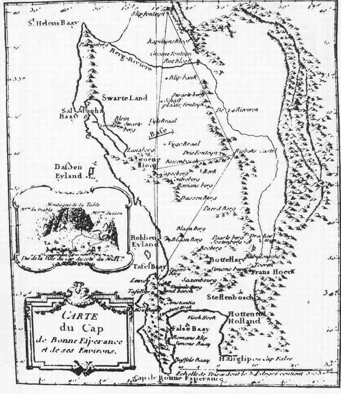
La Caille’s map of his triangulation for measuring an arc of the Meridian. From his Journal Historique, 1763. Courtesy of South African Library. Source: Moore
For verifying many of his Cape observations, La Caille had to know the exact distance between the latitude of his Strand Street observatory and the latitude of the Paris observatory. To measure this with sufficient accuracy, he had to know the true shape of the earth.
In August 1752, he made a preliminary field trip to select a suitable site for the northern point of his Arc. The Southern point, he had already decided, would be his observatory in Strand Street. This was later to prove an unfortunate choice.
The Northern point that he selected was Klipfontein, a farm in the mountains north of Piquetberg. His fundamental baseline, which was eight miles long [12.8 km], was measured on the Darling Flats, using wooden rods. On this base, by observations of angles, he built a series of triangles connecting his Strand Street observatory to Capocberg, not far from Darling, Riebeek Casteel and Klipfontein. The true distance between Klipfontein and Strand Street (the north and south stations) could now be established by calculation. La Caille then made astronomical observations to fix the latitude difference between the two stations. La Caille’s own survey of his arc is shown on his map, reproduced here.
Of course it did not all go smoothly as things never do on expeditions of this sort, which is why they are so fascinating to discuss afterwards. … Governor Tulbagh loaned La Caille some men under the command of Captain E B Muller, an artillery officer who was also the engineer at the Cape Fortress. Also mentioned in the reports, is a man named Poitevin, held by some to have come from France with La Caille – though we have found no proof of this in the documents examined by us.
The party was delayed for eleven days and nights on Riebeeks Casteel by bad weather. The beacon fires on Piquetberg, which were to be used, as fixed points were not kept constantly alight, as they should have been. Not surprisingly, on 11 October 1752 Captain Muller wrote to the Governor requesting a few more days’ leave. One can well imagine the conscientious La Caille’s frustration at the delay, but the support that he received from Muller, must have been a great solace to him. It has been said of the worthy Abbe that he won the love and friendship of all whom knew him. This seems to be borne by the many records that we have of official and private persons rallying spontaneously to his help.
The result of La Caille’s measurements provided a real shock. From it – and he checked his figures with his customary care – the Southern half of the earth was found to be of different shape from the Northern half. It was a prolate or slightly lengthened spheroid instead of an oblate, or slightly flattened one! As we would express it today, La Caille’s single degree of longitude, or Arc of the Southern Meridian measured 111.17 km. instead of 111.30 km. The anticipated value – a discrepancy of 0.13 km.
Of course, with hindsight, we know that La Caille’s measurement was wrong – and we know why. But it took a surveyor of equal stature, a staunch admirer of La Caille, to make the correction, as will be described later.
His measurement of the Arc of the Meridian rounded off La Caille’s work at the Cape and on Thursday 8 March 1753; he sailed for Mauritius aboard the French ship Le Puisieux, none too elated, it is said, by the fact that he was not going straight home to France. When he finally returned to Europe and the College Mazarin at Paris, he deduced a number of important results from his Southern observations. His contributions to science were among the most valuable to be made during the whole of the eighteenth century.
He died at the age of 48, burned out by the intensity of his intellectual fire.” [Copied Moore, pp. 29 – 43.]
|
Maclear’s measurement
“As well as his astronomical work, Maclear took part in land surveys as well as magnetic, meteorological and tidal observations. His most famous survey was the re-measurement of La Caille’s Arc of Meridian to find out if-or where – that great man had gone wrong. To help in this undertaking – in which Herschel gave invaluable advice throughout – the Astronomer Royal, Sir George Airy, sent from Greenwich, the zenith sector that had been used by James Bradley, discoverer of the aberration of light; Bradley had died 75 years before. … “Draft of instructions to Mr Maclear, Astronomer at the Royal Observatory, Cape of Good Hope, in reference to the use of Bradley’s Sector for the verification of La Caille’s Arc of Meridian.
“1. The object of the proposed observations is to verify La Caille’s observations and to explain, if possible the cause of the discordance of La Caille’s result from the results of all similar observations. For the first of these purposes, it is indispensable that the observations be of unexceptional goodness, for which it is presumed that the admirable construction and perfect state of the instrument render it wholly competent. For the second purpose, it is desirable that the observations be made on the same spots on which La Caille made them. Also that similar observation is made at places in the neighbourhood of La Caille’s stations, which are differently situated in regard to the circumstances of geology and physical geography. At the southern extremity of the arc, observations ought to be made as well as at the modern observatory as at La Caille’s station; at the northern extremity the selection of places must depend on Mr Maclear’s judgement.
“II. As soon as Mr Maclear receives the instrument, it will be desirable that he provide a tent capable of covering the tripod stand and surrounding stage, with such equipment as may be necessary for himself and his assistants; together with the means of transportation to the distant stations. In the arrangement of these preparations, assistance will be received from the Office . . .”
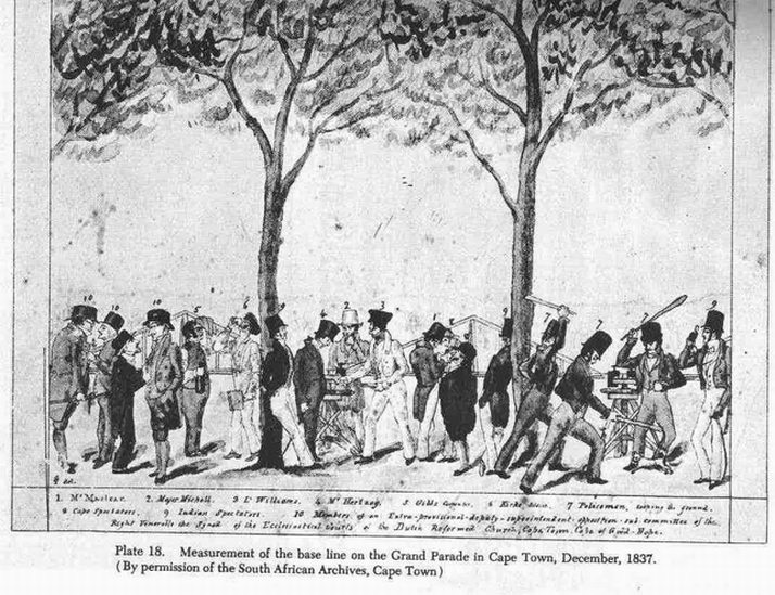
 Measurement of the base line on the Grand Parade in Cape Town, December 1837. Drawing by Charles Piazzi Smyth entitled “a caricature”. Measurement of the base line on the Grand Parade in Cape Town, December 1837. Drawing by Charles Piazzi Smyth entitled “a caricature”.
Courtesy South African Archives. Source: Moore: Warner – Smyth; Evans
It is interesting to speculate as to Maclear’s feelings when he unpacked the crates containing the instrument. It is possible of course, that he had seen it before at the Royal Observatory, Greenwich (it is still there, in what is now called Flamsteed House). The “tent capable of covering the tripod stand and surrounding stage” had to be made seventeen feet high and the colossal instrument, together with its tent and all its trappings, had to lug around by Maclear on all his subsequent geodetic journeys. It travelled hundreds of miles by ox wagon over the trackless veld, even as far as the Orange River; and whether it was always possible to observe the injunctions contained in paragraph VII of Airy’s letter – “As the instrument is of great historical celebrity, it will be Mr Maclear’s duty to preserve it with great care” – is open to the gravest doubt. One pictures the ox wagon containing “the instrument of great historical celebrity” sinking over its disselboom in soft river mud, or slithering to the edge of the precipice on the mountain peak that is now known as the Sector Berg.
During his early years at the Cape, Maclear spent a considerable amount of time and effort in trying to locate the exact site of La Caille’s observatory, together with the survey points, which he used. That he was not entirely successful was not his fault. La Caille did his work eighty years before and since then; there had been a great deal of demolition work as well, as the erection of new buildings. Under the circumstances, Maclear did well to find some of the points – in one case, the ashes of one of La Caille’s signal fires. But on the whole, his only course was to carry out a fresh survey of the same area, fixing new survey points while covering La Caille’s original ground as closely as possible.
Firstly, Maclear began survey operations on a tract of flat ground near the Observatory. Herschel’s role in these proceedings seems to have been what Americans would term that of a “kibitzer” – a person who stands on the sidelines, watching carefully and offering advice. He was certainly helpful. Maclear’s measuring-rods were top-heavy and much of his work was held up when they were blown down or tipped over. Herschel suggested improvements based on his own experience of such matters and they were successfully adopted. Unfortunately, floods washed out the Observatory base line. Maclear managed to measure it satisfactorily at a later date.
For the benefit of other surveyors, Maclear then undertook the laying-out and measurement of a base line on the Grand Parade, Cape Town. In those days his work was done in full view of the public and it seemed to have caused a minor riot. Again the first attempts were unsuccessful and so the base line was measured for a second time on 2 December 1837. This time, with the painstaking accuracy for which Maclear was already known. On either end of the baseline at the Grand Parade Maclear sunk old disused cannons into the ground in order to have a physical standard against which later land surveyors could check their chains. This action laid the basis for land surveying in South Africa. [Warner – Astronomers, p.52.] This feat is even more important when considering that Maclear was a medical doctor turned astronomer. He knew nothing about land surveying and this preparation phase was his self-taught learning phase.
After his geodetic preliminaries, Maclear felt ready to embark on the verification and extension of La Caille’s arc. The fieldwork, which was exhaustive, started in 1838 and continued until 1847 (9 years).
Maclear employed measuring rods, supported on trestles that could be compared with a standard rod brought out from England. The rods were designed not to expand with temperature fluctuations. He would mount the rods on trestles, measure the gap between the rods with a microscope, take a temperature reading for good measure and repeat the exercise. [Warner – Astronomers, p.51.]
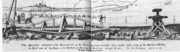
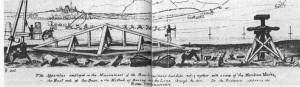 The apparatus employed in the Measurement of the Base Line. Above left in the drawing the Royal Observatory at the Cape of Good Hope is visible.
Drawing by Smythe. Courtesy Royal Greenwich Observatory. Source: Warner – Smyth
The results are given in a monumental publication, “Verification and Extension of La Caille’s Arc of Meridian at the Cape of Good Hope” {two volumes, London 1866, edited by Sir George Airy, Astronomer Royal). As may be imagined that this is an erudite work, great stretches of which are unintelligible to the layman. Only specialists can view the work properly and appreciate the effort that went into it. It was of course an official Cape Observatory publication. Sir David Gill wrote:
“It is impossible to convey within moderate limits an adequate idea of the indomitable energy and perseverance with which this operation was carried out of the difficulties surmounted and of the work accomplished within limited means.”
To help in this survey, Maclear was loaned the services of a party (14 persons [Warner – Astronomers, p.57.]) of sappers from the Royal Engineers at the Castle under the command of Sergeant John Hemming. Fully conscious of the importance of the undertaking in which he was taking part, Hemming afterwards wrote his own account of the expedition. This throws a revealing light on the social conditions of the time:
“A few casualties occurred to the men on the service. One man was unfortunately drowned while bathing, and another was lost while in a state of intoxication by a fall into a deep gully. I got a broken head with a bludgeon from a drunken fellow, but providentially soon recovered.”
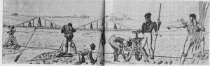 “Modus Operandi” “Modus Operandi”
Courtesy Royal Greenwich Observatory. Source: Warner – Smyth
Apart from the 14 men from the Castle a party of eight Royal Engineers had been sent out from England under command of Captain Alexander Henderson. [Warner – Astronomers, p.57.] Also working on the project were some of the Observatory personnel. There was William Mann from the Royal Observatory and Charles Piazzi Smyth. … Let us pause: Maclear and his assistants toiling over terrain of the worst possible kind, the ox wagon containing the monstrous zenith sector an object of constant apprehensive concern; bedevilled by the antics of the sappers; and grimly determined that, come what may, the end result of the expedition would be an accurate re-measurement of La Caille’s exasperating arc.
And so it proved. To the undisguised relief of all the astronomers and surveyors of the world, Maclear’s results showed that the Earth was indeed the same shape at both ends oblate, or grange-shaped, instead of being flattened in the Northern Hemisphere and rounded in the Southern, as had been feared. Mountain masses at La Caille’s two terminal stations had caused what are termed “discordances”, though no fault could be found with the Frenchman’s careful observations themselves. Many years later, Maclear’s geodetic work led to the setting-up of the official Government Trigonometrical Survey Office of South Africa.
Maclear was indefatigable in the duties of his office. For his work on the re-measurement and extension of La Caille’s arc, he received the Lalande Prize in 1867 and a royal medal in 1869 (Bradley’s zenith sector was returned unscathed to Greenwich in 1850).” [Copied from Moore, p. 47, pp. 55 – 66.]
“A subsequent check also showed that the tape he had used was in error by nearly 10 cm.” [Copied from Smits] |
Simplistic Conclusion:
Lacaille was send out to measure the Arc of the Meridian, a due North – South line in order to supplement similar measurements in the northern Hemisphere. The goal was to determine the size and shape of the Earth. However, something went wrong in measuring his latitude (involving getting his vertical angle’s at either end of the line correct). His hard labour proved that the Earth was pear shaped, not round like an orange.
Eighty years later the Admiralty wanted to solve the mystery. Lacaille’s initial measurement was done before the French Revolution. In the mean time the whole world’s political and social order have changed, and the Cape Colony has changed ownership from a private Dutch Company (Dutch East India Company) to a Colony of the British Empire. Scientific Mysteries in the minds of scientists needs to be solved, even though the world has changed.
The astronomer at the Cape of Good Hope was Thomas Maclear, and acting on a hint by George Everest he solved the mystery. What happened was: Lacaille measured his Arc of the Meridian between two mountains. In setting up his instruments at each end of the Arc required for them to be exactly vertical in order to measure the positions of stars for determining the latitude. The problem was that his instruments were influenced by the gravitational attraction of the mountains (one of them being Table Mountain). A plumb line will not hang exactly vertical next to a mountain, because the gravity will pull it off centre. (If you have the pleasant experience of drinking a cup of coffee at Cape Town, at the foot of Table Mountain, the coffee in your cup will not be exactly level, but skewed a bit by the gravitational attraction of the mountain)
Maclear used a very particular instrument, the Bradley Zenith Sector, which allowed him to accurately make his latitude measurements in the gravitational field of the mountains. By correcting for the gravitational attraction in his calculations he proved the Earth was round, not pear shaped as Lacaille’s calculations showed. Everyone was happy again. |
Archaeological Excavations:
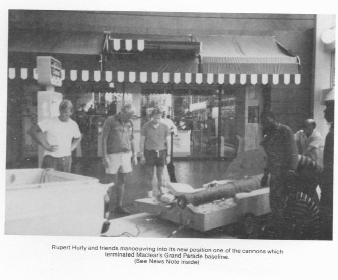
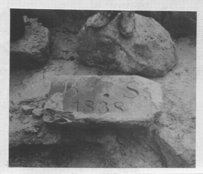
When Maclear measured his baseline on the Grand Parade in Cape Town, he decided to mark out a permanent base line in order that future landsurveyors will have a standard against which to measure their surveyor chains. Thus Maclear buried two old canons with exact precision and plugged a pin into the centre of each barrel. The distance between the two pins for a while became the standard length for South Africa.
When the Golden Acre, a shopping centre in Cape Town was being built, some artifacts were dug up. It was soon realised that a canon which was found was part of Maclear’s baseline.
 Source: MNASSA 1989, Vol.48, No.5, Cover Source: MNASSA 1989, Vol.48, No.5, Cover
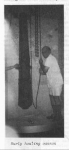
Maclear’s Baseline at the Grand Parade, with Rupert Hurly at the cannon that marked the one marker point.
Source: MNASSA 1989, Vol.48, No.5, p.51

Baseline for Maclear’s Arc of the Meridian.
Source: MNASSA, vol 49, p 173.
|
|
|
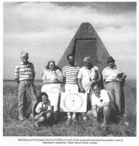
Members of the Cape Centre of the Society (ASSA) visited the two pyramids in the Swartland plains which mark the ends of the the baselind laid out by Maclear between October 1840 and April 1841..
Left to Right: Alan Cameron, Audrey Joubert, Brian Skinner, David van Heerden, Charles Allen, Bianca Skinner and Joe Joubert.
Source: MNASSA 1989, Vol. 48, No. 3, cover.
|
|
Source
Bibliography:
- Amod A, et. al., A History of Geodetic Surveying in South Africa – Part 1, The Cape Odyssey, Historical Media cc, Cape Town, Aug./Sept. 2002 – Vol. 2 Issue 7, pp. 1 – 9.
- Glass, I.S.: “Nicolas-Louis de la Caille, Astronomer and Geodesist”, Oxford University Press, 2012. ISBN 978-0-19-966840-3
- Keay, J. The Great Arc, p.87.
- Moore, P. & Collins, P., Astronomy in Southern Africa, pp. 29 – 43, p. 47, pp. 55 – 66. (General Source)
- Smits P. A Brief History of Astronomy in Southern Africa. (Unpublished).
- Washington History Today
- Warner, B., Astronomers at the Royal Observatory Cape of Good Hope.
Recommended Reading:
- Alder, K. The Measure of all Things, The Seven-Year-Odyssey that transformed the World; Abacus, U.K. 2002.
- Glass, I.S.: “Nicolas-Louis de la Caille, Astronomer and Geodesist”, Oxford University Press, 2012. ISBN 978-0-19-966840-3
- Keay, J. The Great Arc, The Dramatic Tale of how India was mapped and Everest was named; Harper Collins Publishers, London, 2001.
|
|
|
Links
Related Link:
Smyth |